The first Multiplier Event promoted by the MYGEO Project has been held on Monday the 3.5: the MYGEO community responded with great interest and participation!
The event was aimed at collecting good practices and experiences by Academics and professionals making use of GIS tolls in their daily work.
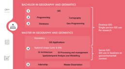
The first session was held by Professor Bart De Wit who illustrated the main features of the bachelor and master courses in Geography and Geomatics offered by the Ghent University.
In particular professor Bart De Wit explained how the courses are focused on the concrete use and realization of online or mobile GIS application: they allow students to learn how to build a geo web platform to collect, analyze and visualize data.
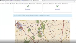
In the following session, Jana presented her GIS tool based project; Jana is a student at Ghent University in Geomatics Land Surveyng and she’s working on the realization of a website for an animal shelter, based on GEO functionalities.
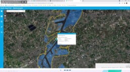
The next topic was held by Alanda Savat, former student from the Ghent University and project manager at GeoSolutions.
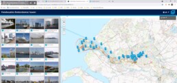
GeoSolutions developed a Geo Counter for the Province of Antwerp, with the aim of making location-based information, useful to the inhabitants, available to everyone.
They created a visual tool accessible to everyone and requiring no prior technical knowledge.
Moreover, she explained the Implementation of Esri GIS software package at North Sea Port, a cross border port between Netherlands and Belgium. The use of GIS at North Sea Port consisted in create, maintain, analyse and publish available and future geographic data and in supporting it’s business process.
Finally, more details about GIS and Advice; how to use GIS as a public relationship and communication tool:
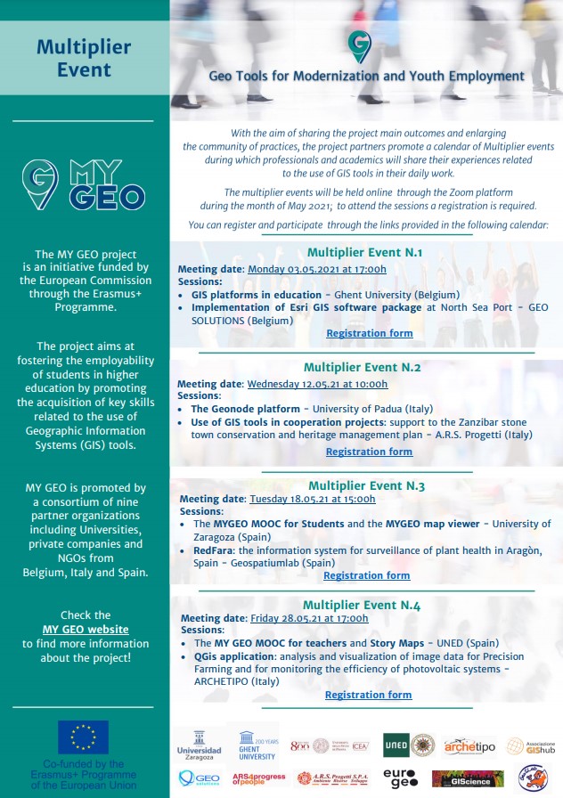
Don’t miss the next MY GEO Multiplier events: see on following the scheduled sessions and the experts involved!
MULTIPLIER EVENT N.2 – Geonode platform – GIS tools 12.5 at 10h
University of Padua (Italy):
The Geonode platform
A.R.S. Progetti (Italy):
Use of GIS tools in cooperation projects: support to the Zanzibar stone town conservation and heritage management plan
Registration Form: https://forms.gle/iCDrUgoLiRnY573k6
MULTIPLIER EVENT N.3 – MYGEO Mooc for students and map viewer – RedFara: surveillance of plant health 18.5 at 15h
University of Zaragoza (Spain):
The MYGEO MOOC for Students and the MYGEO map viewer
Geospatiumlab (Spain):
RedFara: the information system for surveillance of plant health in Aragòn, Spain
Registration Form: https://forms.gle/jAuziAHLHdkHsWDv8
MULTIPLIER EVENT N.4 – MYGEO Mooc for teachers and Story Maps – QGis application 28.5 at 17h
National Distance Education University (Spain):
Story Maps
ARCHETIPO (Italy):
QGis application for the analysis and visualization of image data for Precision Farming and for monitoring the efficiency of large photovoltaic systems
Registration Form: https://forms.gle/9oGevLb6ELRZgpJB7
To attend the sessions a registration is required.
MyGeo Multiplier Event Leaflet