Estate GIS 2021 is the Italian multiplier event of the European Erasmus+ project MyGeo.
The MyGeo Project partner Master in GIScience and Remote Piloted Systems is pleased to invite you to the free and open to the public series of seminars “Summer GIS 2021 – GIS and Science for the climate, society and the territory” .
A cycle of seminars and workshops for all those who want to approach and deepen the world of Geographic Information Systems.
Six events dedicated to GIScience, starting from Wednesday 9 June until 30 August .
SUMMER GIS 2021: Seminars, geoinformatics laboratories and workshops to raise awareness and involve students and citizens on climate change and socio-environmental impacts of anthropic activities on a local and global scale, using Geographical Information Science ( GIScience ) as an interdisciplinary tool for reading and disclosure.
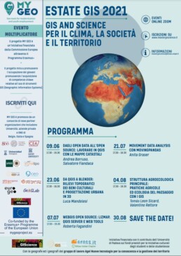
Program:
9 June – 17.30 / 19.30 | From open data to open source: working in QGIS with cadastral maps (Andrea Borruso, Salvatore Fiandaca)
23 June – 17.30 / 18.30 | From QGIS to Blender: topographic surveys of cultural heritage and urban design in 3D (Luca Mandolesi)
7 July – 17.30 / 19.30 | Open source WebGIS: LizMap, QGIS Server and web tools (Roberta Fagandini)
21 July – 17.30 / 19.30 | Movement data analysis with MovingPandas (Anita Graser)
4 August – 17.30 / 19.30 | Main agroecological structure: agroecological practices and landscape ecology with GIS (Tomás Enrique León Sicard, Valentino Giorgio Rettore)
30 August | SAVE THE DATE!!
Methods of delivering the workshops | GIS Summer 2021:
All seminars will be held online through the ZOOM platform. A few days before the event, the link to access the seminar will be sent.
How to register:
To register, you need to fill in the following form.
Upcoming Updates:
To stay constantly updated on all the initiatives of the Master in GIScience and SPR:
- Facebook page – Master in GIScience and drones for land management
- Instagram – @ giscience_unipd
- YouTube – GIScienceTV
- Subscribe to newsletter (monthly)
// Download the complete poster //